Things To See, People To Do
Get the Cluck Over Here!
 General Travel Info:
The Taylor Highway is made of packed gravel. Trucks, cars, and motorhomes regularly travel the road.
The highway is open from Spring to early Fall. Paving is expected in the same year that pigs begin to fly.
From the Lower 48 or Canada:
Take the Klondike
Loop from Whitehorse to Dawson City. Then travel the
Top of the World Highway from Dawson City. This will
turn into the Taylor Highway at the cutoff to Eagle.
Just after you cross Chicken Creek, turn left toward downtown 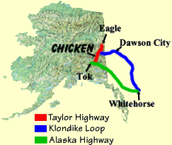 Chicken (which you can't see from the highway.) You will travel 1/8th of a mile
and then you can't miss it!
Chicken (which you can't see from the highway.) You will travel 1/8th of a mile
and then you can't miss it!
From the Rest of Alaska:
Take the Alaska
Highway. 12 miles west of Tok, turn onto the Taylor Highway
cutoff. Chicken is approximately 68 miles from this junction.
Take the first exit to the right. You can't see Chicken from the
road, but it's just 1/8th of a mile off the highway. If you cross
Chicken Creek, you've gone too far.

A "Milepost" travel book is highly recommended for any travel through
Alaska.